
[vc_row full_width=”stretch_row_content_no_spaces” content_placement=”top”][vc_column width=”1/3″] Bioregional Mapping Why It Matters[/vc_column][vc_column width=”1/3″] Tools of Resistance Indigenous Mapping[/vc_column][vc_column width=”1/3″] How to Map a Bioregion[/vc_column][/vc_row][vc_row][vc_column][vc_empty_space][vc_separator][/vc_column][/vc_row][vc_row][vc_column width=”1/4″][vc_widget_sidebar sidebar_id=”pojo-sidebar-76″][/vc_column][vc_column width=”1/2″][vc_column_text]
What is Bioregional Mapping?
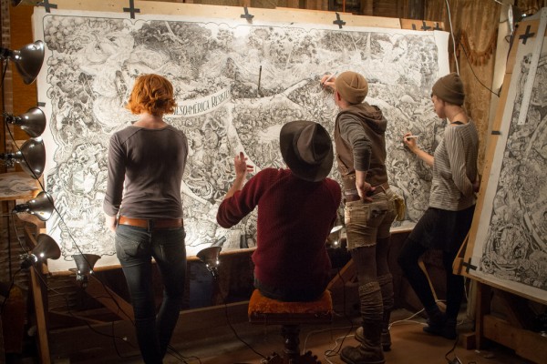
Bioregional mapping is process for creating maps that that set cultural and geographic information into natural boundaries and borders, rather than anthropocentric lines removed from context of place. Maps are not neutral, and many maps today are constructed by governments or economic entities to convey their interests and reinforce their world view. Bioregional mapping is a process which lets us reclaim mapmaking for our own purposes and communities.
Bioregional Maps


Through this process, we are able to represent the physical realities and needs for inhabitants within a region, and develop measurable bioregional frameworks for healthier societies able to live within the contexts and constraints of each region.
Bioregional mapping is a community and participatory process to create maps that combine ecological and physical information with social and cultural information within a given place, as defined by those living there or the communities most impacted. It is both a tradition that dates back thousands of years, inspired by countless forms of Indigenous Mapping, and also that has emerged as a direct and modern response to the erasure of local cultures in the face of our current ecological, economic and social crises.
Creating a better world is more than just abstract principles and ideas, and if we want to build that world – then we need to know how to connect it in with our society, and the places we lived, as defined and inspired by those living there. Just as we want to democratize our economic and political systems, we must start to democratize and localize our own maps – in how we receive and get our information, and how we connect to and relate to our home places.
Bioregional maps are mapped based on what they find important, not based on what economic or national interest has the highest stake. And rather than highly trained and paid experts – it puts the responsibility and learning back into our own hands – we are all the expert. Through knowing our own backyards, it breaks down arbitrary and national boundaries that are negative or toxic, and leads to pathways for reinhabitation through a subversiveness of place.
“The atlas should be used as a jumping off place for decision making about the future. From the holistic image of place that the maps collectively communicate, what actions could be adopted to achieve sustainable prosperity? What priorities emerge from a survey of damaged lands and unsolved social ills? What underutilized potentials can be put to work to help achieve sustainability? The atlas can become a focus for discussions setting a proactive plan for positive change.”
Sheila Harrington
Giving the Land a Voice: Mapping our Home Places (1995), Salt Spring Island, B.C.
There is no such thing as good mapping or bad mapping. Just different styles of maps that convey different sets of information for different purposes. By decolonizing our mapping processes, we use mapping as a tool to empower a whole generation of barefoot cartographers – every person to learn more about where they live and conceptualize pathways for a better world.
Individual and communities can use bioregional mapping to protect the “cherished spaces” and create new community places reflective of our values. For many communities, what is happening on the ground and in the day to day of a community is unmapped.
How can we map the future or values we would like to translate and share elsewhere if we don’t have a solid grasp for our own backyards or what is important now?
While not every map will be at the scale of a bioregion, if you extend mapping beyond the parcel level or from a national or arbitrary boundary to a neighborhood, natural, watershed or other region that shares biological and cultural boundaries, you are creating a bioregional map.
Bioregional mapping is the art of making people care.
The goal of bioregional mapping is to help humans collectively re-inhabit the continents and bioregions that they live within. It encourages lifestyles that are healthy and democratic, self resilient communities living within the a sustainable carrying capacity for their area, and more so working to actively regenerate their region and world. It is also a deeply personal tool, as a person charts their own experiences, getting to know their home places, and makes every person an expert, and a part of this process.
As a place based ethic, bioregionalism fundamentally challenges us to rethink our relationship to each other and the places that we live, not just along human made lines, but in ways that consider the interconnected whole; all inhabitants, not just the humans living within a place. Because of this, bioregional mapping is a fundamental tool of bioregionalism. With it, we can map our water comes from, different communities of inhabitants who might affected, who originally lived where they now do, where their food comes from, where their waste goes; local plants, animals and how these might change with the seasons.
While it seems simple, these first steps that a bioregionalists takes can be incredibly powerful, revolutionary to some. Most importantly, by helping someone to better know their home, it challenges us to reconceive how we relate to place, breaks down established mental and physical boundaries and if done properly, and most importantly, can get someone to care. By taking these first steps, we cease to be American or Canadian and become citizens of our neighborhood, our watersheds, bioregions and places that are meaningful to us.
Bioregional maps are effective because culture stems from the shared experiences and concerns that grow from sharing place. They employ the knowledge and wisdom gained from understanding experiences with niche ecosystems of place.
Beyond a map on a screen, or lines on paper, bioregional maps can be stories told around a campfire, sung, danced, quilted, painted, posted or however best communicates the purpose that participants want to communicate. One important feature is that bioregional maps are also often concerned with with time – stories from the past, things that people find important to share or groups that are making a difference today, and lastly mapping regenerative and sustainable futures that we want to see. From these community maps, we can create road maps to ideas that might not have existed before, with tangible steps for how to get there. Bioregional mapping tends to be concerned with everything that current mapping is not – everything left off of google maps, or in between the road maps of interstates, gas stations and fast food restaurants.
The plants, the trees, the animals, our stories and lived experiences. Everything that makes a place special. The last little batch of old growth in a neighborhood, the last hawthorne bush planted by your grandmother, the crazy lady with the chickens next door, the homeless encampment down the way, or colorful mural. Untold and forgotten histories of discrimination, genocide or earlier strategies of resistance more important than ever now to tell. Or maybe it’s the type of birds or fish that migrate with the type of season. The rivers that carry the fish, or the bushes that provide unique nesting for native bird species. Stories of the places that make living here special, that define what we think of as home.
Ultimately, we will never accomplish real change by working within the cartography of capitalism or the nation state, nor will we be able to achieve a future that we cannot clearly envision or articulate. Instead, new maps will be needed, and new processes that involve all of us required. Just as we must work to democratize the ways we live and the societies we live in, a new form of map making is needed.
By mapping our home places, and the things we find special, we challenge these perceived notions, and chart pathways to new realities and futures for how our society can live.
Ecological Maps vs. Bioregional Maps:
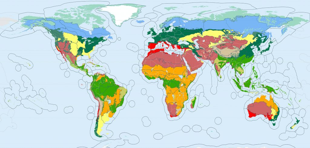
Bioregional maps bring together many layers that help denote the physical and cultural realities of a place. Not all ecological or watershed maps are bioregional maps. The maps used in these examples are certainly ecological maps, but are they maps of actual bioregions? .
Notice in maps like the one above, that only use biomes, terrestrial regions or ecoregions of specific type as their base that often they miss the unique niches that derive from each place. In the above example, from the Bioregions 2020 project you can see that in areas like Northern Africa large bioregional bands stretch stretch from sea to sea, ignoring important watersheds such as the Nile River, and cultures that stretch back thousands of years.
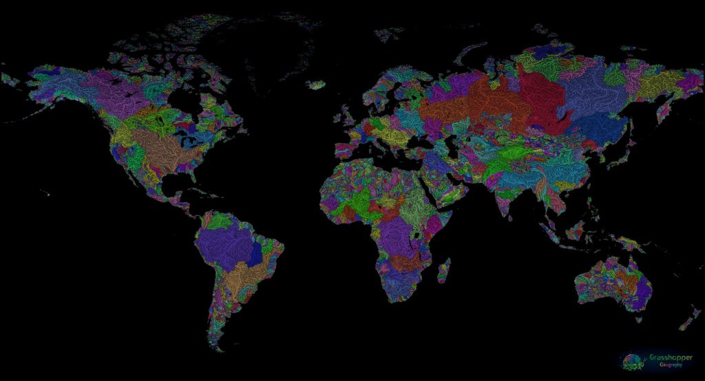
Even this beautiful map by Robert Szucs of the watersheds of the world, is not quite a true bioregional map. Instead, it’s a layer, it’s only when many layers of place, including animal and plant communities are brought together that we see a true bioregional map. When these layers are brought together, it can better represent the geographic, cultural, historic and ecological realities of a place, and guide us towards more place appropriate ways of living and technology that can fit within a truly net carbon, non-extractive and sustainable framework.
Ultimately we need a shift in how we map – how we create our maps, how we view ourselves within maps, and how we interact with them. Bioregional mapping is as much of a process that starts with the watersheds, the communities living there, working its way up, rather than just being able to loosely be made by some small group of folks and labelled and claimed. Every map is political and has a purpose behind it. Bioregional mapping is an opportunity for each of us, and our communities, to map the things we find important, capture the things we want to share, and change our relationship with how we perceive and operate within the world. Every map that inspires the imagination away from a map created in a nation state border, is a map that can change the future.
While these maps are fantastic frameworks for shifting action, and letting people plug in locally, they examples of ecological maps. And while it is a great tool in helping ground and center learners in a map outside of an international context or framework, it can become damaging if used as a basis for development and investment while disconnected from these other elements.
[/vc_column_text][/vc_column][vc_column width=”1/4″][vc_single_image image=”1614″ img_size=”medium” add_caption=”yes” alignment=”center”][vc_separator][vc_column_text]
Some defining features of bioregional maps:
- Every person is an expert, and has something valuable to contribute, to document to share. This can include narratives, histories, stories, things people find special, or knowledge relating to place. Bioregional maps are generally created or defined by communities living within or affected by the topic of the map.
- Temporal. Bioregional maps often include time. How a place changes or is different in each season, or from one year to the next. How animals, glaciers or fish migrate or move. In addition it can map past, present and future – and create roadmaps to societies or things we want to build.
- Bioregional maps can use a wide array of methods to convey information, including song, dance, stories, sign languages, music, social mapping, cognitive mapping, and many other means that individuals feel best able to represent information.
- Many indigenous forms of mapping are inherently bioregional forms of mapping. This includes family and clan relationships, traditional territories and boundaries, relational maps such as to bodies of water, stars and sky.
- As a rule, if you see straight lines on a map, whether it is dividing a continent (Africa, Australia etc.), a community (US political districts, gerrymandering), roads (Google Maps) it is not a bioregional map.
Bioregional maps use ‘layers’ that together can better represent a place. These can include:
- Physical: Geology, tectonics, subduction zones, mountains, peaks, ridges, valleys, rainfall, wind patterns, and how they change over time.
- Biotic: Plants, animals, soils. Growing conditions. How animals and plant nations within an area interrelate, and how they change over time.
- Human: Lessons of living in place, indigenous ways of living and knowledge. Culture, economy, politics. agriculture, energy. History, the context and understanding of past and present, and visions for the future that can serve as roadmaps for how we can get to the future.
When possible we set the biotic and temporal elements (x axis) within the physical reality of place (y axis) and document how it flows with the passing of time (z axis).
Bioregional maps are not made from one layer of information, but rather atlases in which layer upon layer has been added, from which shapes and deeper lessons emerge.[/vc_column_text][/vc_column][/vc_row]