[vc_row full_width=”stretch_row_content_no_spaces” content_placement=”top”][vc_column width=”1/3″]Bioregional MappingWhy It Matters[/vc_column][vc_column width=”1/3″]How toMap a Bioregion[/vc_column][vc_column width=”1/3″]Bioregional MappingWorkshop[/vc_column][/vc_row][vc_row][vc_column][vc_empty_space][vc_separator][/vc_column][/vc_row][vc_row][vc_column width=”1/4″][vc_widget_sidebar sidebar_id=”pojo-sidebar-76″][/vc_column][vc_column width=”1/2″][vc_column_text]
What is Indigenous Mapping?
“For far too long Indigenous peoples have been excluded from the map. We’re changing that.”
– Steve DeRoy
Founder, Indigenous Mapping Workshop
Mapping is a powerful tool that holds stories. But who controls the narrative? Historically, maps were created by professional cartographers, many of whom played a large role in colonization. These maps have shaped the way many of us see the world today. Of course, that begs the questions, who or what is left out of the map and how can that be changed?
Indigenous mapping is a practice where Indigenous communities own, control, access, and possess both the geographic information and mapping processes. For many Nations it is also a critical step to reclaim territories which have been erased off of maps created by western corporations and governments, and an invaluable tool in legal cases to recognize their heritage and treaty rights.
Reclaiming Indigenous Lands Through Mapping
For many Indigenous communities, mapping plays a large role in reclaiming their lands. Mapping is not new to Indigenous peoples, in fact, some of the world’s earliest maps can be seen in cave paintings or heard in the stories that have been passed down through generations. Today many Indigenous communities across Turtle Island and beyond use cartographic mapping to track traditional knowledge of their lands and waters.
Rather than rely on the framework of western maps that often serve to show and reinforce the political and economic control – cities, roads, highways, railroads, federal and state designations, instead they use bioregional mapping. These maps can show sacred sites, the paths of moose or caribou, the best areas to find a particular species of fish, where to pick traditional medicine and much more. Maps are often used when major projects such as mines or oil rigs are proposed on Indigenous land; they illustrate potential impacts these projects could have on the environment and the communities’ way of life. These techniques create more holistic maps that bring in family histories, culture, stories, territorial control, animal migrations, seasonal differentiation, and a wealth of GIS data related to environment, topography and geography.
Bioregional Mapping vs. Indigenous Mapping
Indigenous mapping is a form of bioregional mapping with a specific context and use in which Indigenous communities communities own, control, access, and possess both the geographic information and mapping processes. It helps protect community knowledge and well being, and is used to assert Indigenous knowledge and control in arenas where traditional knowledge and ways of living are not given the same legal standing as colonial practices.
Bioregional mapping is a grassroots technique and method of making maps which can be used by any community, organizer to help people better educate and connect to place. Bioregional maps convey a sense of place, time, stories and narrative and is a form of counter-mapping that helps re-assert control and perceptions of spatial geography. The two fields have played an increasingly important role in challenging dominant narratives, using maps as grassroots tools of resistance and democracy, asserting voices and control of territory by those often shunted to the side of “official” government and corporate practices, and reimagineering spatial realities and futures that we can be actively working towards.
Indigenous perspectives on territories and resources through spatial representations are incredibly important for contemporary issues of sustainability, human rights and climate change. Many Indigenous communities fighting against extractive industries are often at the forefront of broad and urgent environmental threats, and a deeply intertwined issue we all need to be active and a part of.
Mapping as tools of Resistance
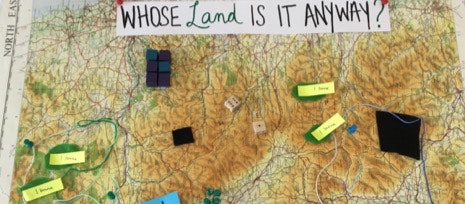
Whose Land is it Anyway? (crafted by Charlotte Adams, Kaitlin Kok, Melissa Castron, Tom McGurk, Mary Kate Craig, Sébastien Caquard – Aug. 2018)
Over the past several hundred years, maps have served as colonial and nation-building tools as they project a spatial vision of a nation that can easily be managed, planned and subjected to militarization. Maps have been largely used as tools for accumulation and control by the state, the industries, the church and other powerful institutions while the interests and needs of subaltern populations were ignored. Domains were left in the realm of “experts”, and even today represent the priorities of those who can often afford to make them. For governments, it’s laying out the political administrative units. Roads that are maintained, and the
Opposing these mapping practices, we argue that mapping can be reclaimed and used for social justice. With progressive goals, these counter-mapping projects grapple with how to articulate space not just to appropriately represent the everyday geographies inhabited by marginalized populations. They also provide mechanisms to criticize neoliberal projects, to build stronger alliances among groups and to expose the malevolent geographies of accumulation and dispossession which are behind the contemporary developments in the Philippines. Further, these projects reflect the multiplicity of counter-cartographic initiatives that often entail engagements across various sectors, from university students to people’s organizations.
Counter-mapping brings together these multiple visions of space. As an antidote to the fixed and final partitioning of space by the state, counter-mapping sees maps as processes and encounters that recognize multiple spatialities operating simultaneously. By counter-mapping national spaces of development, we therefore expose the contested visions of development. We consider participatory methods and art as creative and effective means for counter-mapping that challenge the state’s spatial vision.
Maps as a weapon to resist extractive industries on Indigenous territories
For Indigenous peoples across the Americas, urgent threats imposed by the industrial extraction of natural resources has characterized the 21st century. The expansion of industry has threatened Indigenous territories, cultures and sovereignty. These industries include: timber and pulp extraction, mining, oil and gas and hydroelectric development. As well, the extraction of human beings from their lands has real implications for the survival of communities.
The debate of territory is essential in these resource conflicts. Maps — and those who make and shape them — are central to the discussion of land rights, especially when it comes to industrial resource extraction and Indigenous peoples.
Maps as resistance
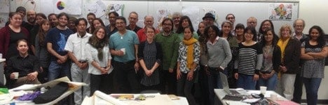
Participants of the MappingBack workshop in Montréal, Oct. 15, 2017.
There is a long history of the use of maps and cartographic techniques by countries and governments to claim ownership over Indigenous territories. But since the 1990s, Indigenous communities have been deploying mapping tactics as a mode of Indigenous resistance, resurgence and education. These tactics use historical memory and ancestral knowledge to assert territorial rights and community visioning.
Indigenous communities have either led or collaborated with multiple players to launch a broad array of mapping projects as a way of reclaiming ownership on the multiple aspects of their territories. These projects range from low-tech community mapping approaches to the use of the latest online web mapping technologies.
Indigenous peoples conceive the diverse range of Indigenous territories as spaces of living relations; they are homelands since the beginning of creation; they are the reserve lands of forced resettlement, or they are spaces of refuge away from the violence and pressures of settler societies.
Tsleil-Waututh First Nation Bioregional Atlas
In 1997 the Tsleil-Waututh First Nation, with a 720 square mile traditional territory in BC’s lower mainland, pioneered use of bioregional mapping as a means of furthering their interests in both treaty negotiation and community building processes. The Tsleil-Wautt people created a forty sheet bioregional atlas that describes a collectively held “vision” of how their culture has evolved in the past, has survived in the present, and how it will grow in the future. The bioregional atlas format has allowed a vast amount of often complex information to be presented in a relatively inexpensive format that is accessible.
It was used as a primary document in several legal cases recognizing their authority over their territory, and taken all the way to the Canadian supreme court. The Tsleil-Waututh Nation Bioregional Atlas was created by following steps including:
A large “in house” research library was assembled;
A 1:100,000 scale 2′ x 3’digital map base was constructed using a CAD program (Microstation);
A three part research process was carried out. First, libraries, archives, and government offices were “plundered” for reports, maps, and other useful information. Second, local community members were interviewed for their traditional knowledge of history, legends, and material culture. And third, data contained in existing reports prepared by the Tsleil-Waututh Nation were distilled into visual formats.
A series a draft “doodle” maps were created with assistance from community members. These maps were continuously added to and revised;
All available biophysical and cultural information was translated into a digital mapping format;
Draft and final maps were checked by numerous community groups:
Lands and Resources Committee,
Treaty Caucus,
Traditional and Elected Councils.
Community Open House;
Once approved, the map atlas has been used for treaty negotiations, economic development, public education, cultural protection and other purposes.
The first series of maps was finished in November 1997. They are organised in 7 “chapters” to tell a story of the Tsleil-Waututh Nation. The chapters, each which include 1-10 maps, are:
Biophysical Setting
Patterns of Traditional Use
Impacts of Colonialism
Current BC and Canadian Jurisdictions…”Power” Maps
Tsleil-Waututh Nation Stewardship Vision
Watershed Unit Plans
Variable Title Approach to Urban Treaty Settlement
By 1998 the maps had been presented on more than 40 occasions to government officials, university classes, corporations, Tsleil-Waututh community members, and other community groups. The overwhelming response has been that the atlas presents the worldview and political aspiration of a First Nation in a manner that has rarely been achieved in the past. The bioregional atlas continues to expand and change. Community members use individual maps for public presentations, and as part of school projects. The bioregional mapping library is visited for a variety of research purposes. The bioregional atlas is working as intended. On one level the atlas has assisted in advancing treaty negotiations, on another it is working to build community.
During the same time period, not too far away, the Nisga’a people were developing maps that that helped locate their boundaries of extended family territories, and with a team of trained local interviewers, marked hundreds of place names in the Nisga’a language. Using these base layers, they digitized this information and using GIS and satellite images to defend their sovereignty against the Canadian government, and aid in the stewardship of their locally controlled forests, fisheries and other resources.
The Gitksan and Wet’suwet’en, neighbors of the Nisga’a, have also recorded information by reviewing Elders. The recordings were used as primary source material then to make an atlas representing a holistic image of how these two people steward and inhabit their territories. The maps, created with the help of Canadian cartographer Louis Skoda, used beautiful images to describe home. How people migrated to their present territories, the meaning of ancient place names, where berries grow, where and how to catch salmon. And more than that, have been used as an underpinning for a legal challenge against imposed control over their territories. Despite being created more than 20 years ago, these atlases have created a legal framework very much still in contest today, with ongoing direct confrontations against corporations and the Canadian military – who are attempting to build gas and oil pipelines that would connect Alberta to expanding markets in Asia, despite ongoing resistance from First Nations whose territory they illegally cross.
Decolonize the Map. Indigenize It. Mapping Conferences & Groups
Since 2014, there have been regular workshops, conferences and classes bringing together new generations of indigenous mappers, cartographers, policy planners and educators. These events now happen multiple times a year, in many different locations around the planet.
Some great organizations to connect with if you are interested:
The United States and Canada are foundationally broken systems.
When Indigenous Nations entered into treaties with the United States, France and Britain, they never intended to transfer ownership as it is know thought of by the United States and Canada. There was never the legal consideration from Indigenous Nations (i.e., a land transfer offer) required for the land to be given, and in many cases treaties were signed under extreme duress, including enslavement, starvation, torture and genocide. Terms we now equate with war crimes and crimes against humanity. Treaties allowed settlers to occupy lands, and both sides promised to work in harmony and to be peaceful with one another, but colonizer states have often used violence, broken the terms of the agreements, and in some cases still occupy unceded lands. Relying on “Manifest Destiny”, that the land was “unclaimed”, “unused” or “undiscovered”, the hundreds of nations still occupying our continent were ignored, and new colonists created the legal fiction that the land could be “owned”, and that the constitution granted the right to such “unclaimed” territory. For hundreds of years indigenous, black, immigrant populations and women were disenfranchised from participating in this system, while populations, cultural traditions were exterminated.
Even today, the US constitution forces itself, and it’s subdivision of territory as private property into smaller and smaller parcels as the “supreme law of the land”, and does not allow for “tribal nations” to exist as anything but “domestic dependent nations“. Never can they exist as anything more than that, or have true independence, self governance or sovereignty. In Canada, the government routinely ignores the conditions laid out in existing and modern treaties, and still claims sovereignty over, and exploits resources from unceded lands actively being lived on and used by First Nation people, and over their direct opposition and resistance.
Land Back needs to happen so all other aspects of Indigenous livelihood can return with it, and that we can build a system for all of us living here, that starts will of us living here included. Land Back means nourishing our relationship to all things on the land, but it would also mean getting back in touch with languages, traditional familial and governing systems, and creating a better relationship with healing and medicine. It also means having an open conversation about past seizures of land, paying fair rent for resources in continual use and just compensation. Only when all of us are at the table, in an equal way, can we begin to have that conversation of what that, and equal governance may look like.
Examples of these types of shared stewardship can be found in systems like that of the Maori and New Zealand, which are continuing to develop tools of shared governance, stewardship, and approval processes that use aboriginal principles and standards for decision making.
What about lands where the Indigenous territory spans colonial borders, like provinces or the U.S. border? How would you approach those?
Borders are a colonial construct. The land and people living here preceded the creation of borders, and these arbitrary borders must be dismantled. Any border was imposed unilaterally, without consulting the Indigenous Nations that would be impacted. Resolving these issues is not difficult. Indigenous Peoples, Indigenous Nations must be included from the bottom up, in discussions about interprovincial borders, and the shared management of resources within those borders. Instead of nation states – we like to think of working towards “nature states” or bioregions as our natural countries of the planet – within them that can contain many nations, cultures, ecosystems and watersheds. Natural boundaries, cultures, histories, fish, plants, animals and ecosystems should also be considered. Between Canada and the U.S., any person of Aboriginal descent should have free passage over the the US/Canadian and US/Mexican border.
From the start, we must entirely rethink our conception and framework for what nations, communities and borders can be. Rivers are borders. Mountains are borders. How birds migrate, animals roam, fires burn, food grows, water flows are all borders that matter quite a lot. How can we envision bioregional administrative frameworks based on overlapping needs and use based on systems of abundance and co-operation, rather than scarcity and privatization, as best determined by those most impacted? What can we learn from place appropriate technologies and ways of living that have been practiced for thousands of years? Rather than citizens of arbitrary nation states and lines drawn on maps by people who have never set foot there, we must become citizens and stewards of our watersheds, and find ways for the millions of people living within these territories to find ways to do so in positive, voluntary ways. A lot of the future of our planet depends on it. Names don’t matter, but where we live does. Where we are born or from doesn’t matter too much, but where we are living now, and how we are living are important.
What does Landback mean in a global sense?
Even if the United States and Canada continue to ignore Indigenous sovereignties, decolonization is the future. The Cascadia bioregion was one of the last places settled by colonizers in North America and around the world hundreds of new peoples have regained acknowledgement of their sovereignty and personhood through the United Nations Declaration of Indigenous Rights. The US and Canada are no different. But even the term “United Nations” and “international” must be examined, as it uses the context of the nation state, and the colonizer as it’s default.
Does land back mean exclusion of people from colonial descent?
No. While this is an incredibly complex issue, involving generations of trauma, cultural erasure and displacement, we cannot and should not support ethno-states, no matter the intention. It is clear in the world the harm that can come from including some, while excluding others based on birth, nationality or race. Instead we must strive for systems of reparations, truth, reconciliation, and making sure there is real means for cultural expression, inclusion and governance.
However, while displacement and erasure are not core values of the Land Back movement; violent, extractive and capitalistic goals and practices are not welcome.
In the case of many US and Canadian Indigenous Nations, the Bureau of Indian Management has ruled Native Nations as puppet states, degraded the quality of life to a third world nation and created systems of abject poverty, and when expedient abolished Indigenous Sovereignties with the swipe of a pen. Blood lines have been used a tool to divide and deny benefits for tribal members and exclude benefits, rather than include them. While the choice should be one made by each Indigenous Nations as they choose – time and time again, when given the chance, Indigenous Nations choose to govern in manners which include everyone, for the benefit of all inhabitants and the land itself, from a generational approach, rather than only humans or some particular subset of human. Together, we must fundamentally rethink and challenge the notion of citizenship assigned by birth itself.
What are some good examples of Land Back?
One of best examples of Land Back in North America is the Yukon Land Claims, which included negotiating and settling Indigenous land claims between First Nations and the Canadian government. Based on historic occupancy and use, First Nations claim basic rights to all the lands they occupy. These nations never signed any treaties, and the lands were unceded even though Canada claimed sovereignty over them. Chief Jim Boss of the Ta’an Kwach’an had requested compensation from the Canadian government for lost lands and hunting grounds as a result of the Klondike Gold Rush as early as 1902, which was promptly ignored. It was not until the 1973 that the issue was raised again in 1973 with the publication of Together Today For our Children Tomorrow by Chief Elijah Smith. Negotiations took place in the late 1970s and early 1980s, culminating in an agreement which was ultimately rejected.
Negotiations resumed in the late 1980s and culminated to the “Umbrella Final Agreement” (UFA) in 1990. The UFA is used as the framework or template for individual agreements with each of the fourteen Yukon First Nations recognized by the federal government. It was signed in 1993 and the first four First Nations ratified their land claims agreements in 1995. To date (January, 2016), eleven of the fourteen First Nations have signed and ratified an agreement. Presently, White River First Nation, Liard First Nation and Ross River Dena Council are not negotiating. They remain Indian Bands under the federal Indian Act.
Unlike most other Canadian land claims agreements that apply only to Status Indians, the Yukon First Nations insisted that the agreements involve everyone they considered part of their nation, whether they were recognized as Status Indians or not under federal government rules. If you look at MTAs, particularly more recent ones like the Yukon Umbrella Final Agreement, signed in 1993, you will see there is language about including Indigenous Peoples in decision-making over the land, waters, and resources in those Nations’ traditional territories. This kind of relationship between Indigenous Nations and Canadians is one of the closest Land Back situations we have gotten to date. However, Canada still breaks these agreements at a similar rate as the other treaties made over the past 300 years (see the Supreme Court decision Nacho Nyak Dun v. Yukon).
[/vc_column_text][/vc_column][vc_column width=”1/4″][vc_single_image image=”1614″ img_size=”medium” add_caption=”yes” alignment=”center”][vc_separator][vc_column_text]
Some defining features of bioregional maps:
Every person is an expert, and has something valuable to contribute, to document to share. This can include narratives, histories, stories, things people find special, or knowledge relating to place. Bioregional maps are generally created or defined by communities living within or affected by the topic of the map.
Temporal. Bioregional maps often include time. How a place changes or is different in each season, or from one year to the next. How animals, glaciers or fish migrate or move. In addition it can map past, present and future – and create roadmaps to societies or things we want to build.
Bioregional maps can use a wide array of methods to convey information, including song, dance, stories, sign languages, music, social mapping, cognitive mapping, and many other means that individuals feel best able to represent information.
Many indigenous forms of mapping are inherently bioregional forms of mapping. This includes family and clan relationships, traditional territories and boundaries, relational maps such as to bodies of water, stars and sky.
As a rule, if you see straight lines on a map, whether it is dividing a continent (Africa, Australia etc.), a community (US political districts, gerrymandering), roads (Google Maps) it is not a bioregional map.
Bioregional maps use ‘layers’ that together can better represent a place. These can include:
Physical: Geology, tectonics, subduction zones, mountains, peaks, ridges, valleys, rainfall, wind patterns, and how they change over time.
Biotic: Plants, animals, soils. Growing conditions. How animals and plant nations within an area interrelate, and how they change over time.
Human: Lessons of living in place, indigenous ways of living and knowledge. Culture, economy, politics. agriculture, energy. History, the context and understanding of past and present, and visions for the future that can serve as roadmaps for how we can get to the future.
When possible we set the biotic and temporal elements (x axis) within the physical reality of place (y axis) and document how it flows with the passing of time (z axis).
Bioregional maps are not made from one layer of information, but rather atlases in which layer upon layer has been added, from which shapes and deeper lessons emerge.[/vc_column_text][/vc_column][/vc_row]